Wolica | |
|---|---|
Village | |
  Wolica | |
| Coordinates: 50°27′14″N 21°10′45″E / 50.45389°N 21.17917°E | |
| Country |  Poland Poland |
| Voivodeship | Świętokrzyskie |
| County | Staszów |
| Gmina | Łubnice |
| Sołectwo | Wolica |
| Elevation | 166.4 m (545.9 ft) |
| Population (31 December 2009 at Census)[1] | |
| • Total |  255 255 |
| Time zone | UTC+1 (CET) |
| • Summer (DST) | UTC+2 (CEST) |
| Postal code | 28-232 |
| Area code | +48 15 |
| Car plates | TSZ |
Wolica[2][3][4] [vɔˈlit͡sa] is a village in the administrative district of Gmina Łubnice, within Staszów County, Świętokrzyskie Voivodeship, in south-central Poland. It lies approximately 6 kilometres (4 mi) north-east of Łubnice, 12 km (7 mi) south of Staszów, and 62 km (39 mi) south-east of the regional capital Kielce.[5]
Demography
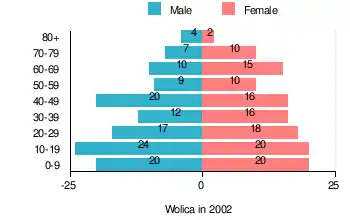
According to the 2002 Poland census, there were 250 people residing in Wolica village, of whom 49.2% were male and 50.8% were female. In the village, the population was spread out, with 32.4% under the age of 18, 32.8% from 18 to 44, 17.6% from 45 to 64, and 17.2% who were 65 years of age or older.[1]
Table 1. Population level of village in 2002 — by age group[1] SPECIFICATION Measure
unitPOPULATION
(by age group in 2002)TOTAL 0-9 10-19 20-29 30-39 40-49 50-59 60-69 70-79 80 + I. TOTAL person 250 40 44 35 28 36 19 25 17 6 — of which in % 100 16 17.6 14 11.2 14.4 7.6 10 6.8 2.4 1. BY SEX A. Males person 123 20 24 17 12 20 9 10 7 4 — of which in % 49.2 8 9.6 6.8 4.8 8 3.6 4 2.8 1.6 B. Females person 127 20 20 18 16 16 10 15 10 2 — of which in % 50.8 8 8 7.2 6.4 6.4 4 6 4 0.8
Figure 1. Population pyramid of village in 2002 — by age group and sex[1]
Table 2. Population level of village in 2002 — by sex[1] SPECIFICATION Measure
unitPOPULATION
(by sex in 2002)TOTAL Males Females I. TOTAL person 250 123 127 — of which in % 100 49.2 50.8 1. BY AGE GROUP A. At pre-working age person 81 43 38 — of which in % 32.4 17.2 15.2 B. At working age. grand total person 126 64 62 — of which in % 50.4 25.6 24.8 a. at mobile working age person 82 38 44 — of which in % 32.8 15.2 17.6 b. at non-mobile working age person 44 26 18 — of which in % 17.6 10.4 7.2 C. At post-working age person 43 16 27 — of which in % 17.2 6.4 10.8
References
- 1 2 3 4 5 "Local Data Bank (Bank Danych Lokalnych) – Layout by NTS nomenclature (Układ wg klasyfikacji NTS)". demografia.stat.gov.pl: GUS. 10 March 2011.
- ↑ Bielec, Jan (ed.); Szwałek, Stanisława (1982). Wykaz urzędowych nazw miejscowości w Polsce. T. III: P – Ż [List of official names of localities in Poland, Vol. III: P – Ż] (in Polish). Ministry of Administration, Spatial Economy and Environmental Protection (1st ed.). Warsaw, Poland: Central Statistical Office.
{{cite book}}:|first1=has generic name (help) - ↑ Sitek, Janusz (1991). Nazwy geograficzne Rzeczypospolitej Polskiej [Geographical names of the Republic of Poland] (in Polish). Ministry of Physical Planning and Construction, Surveyor General of Poland, Council of Ministers' Office, Commission for Establishing Names of Localities and Physiographical Objects (1st ed.). Warsaw, Poland: Eugeniusz Romer State Cartographical Publishing House. ISBN 83-7000-071-1.
- ↑ "Wolica, wieś, gmina Łubnice, powiat staszowski, województwo świętokrzyskie" [Wolica, village, Łubnice Commune, Staszów County, Świętokrzyskie Province, Poland]. Topographical map prepared in 1:10,000 scale. Aerial and satellite orthophotomap (in Polish). Head Office of Geodesy and Cartography, Poland, Warsaw. 2011. geoportal.gov.pl. Retrieved 27 April 2011.
- ↑ "Central Statistical Office (GUS) – TERYT (National Register of Territorial Land Apportionment Journal)" (in Polish). 2008-06-01.
| Seat | _COA.svg.png.webp) | |
|---|---|---|
| Other villages | ||
| Parts of village |
| |
| Hamlets of village |
| |
| Colonies |
| |
This article is issued from Wikipedia. The text is licensed under Creative Commons - Attribution - Sharealike. Additional terms may apply for the media files.