South Carolina Highway 79 | ||||
|---|---|---|---|---|
 | ||||
| Route information | ||||
| Maintained by SCDOT | ||||
| Length | 9.340 mi[1] (15.031 km) | |||
| Existed | 1938–present | |||
| Major junctions | ||||
| South end |  SC 9 northwest of Bennettsville SC 9 northwest of Bennettsville | |||
| North end |  NC 79 at the North Carolina line northeast of Boykin NC 79 at the North Carolina line northeast of Boykin | |||
| Location | ||||
| Country | United States | |||
| State | South Carolina | |||
| Counties | Marlboro | |||
| Highway system | ||||
| ||||


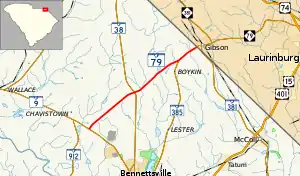
South Carolina Highway 79 (SC 79) is a 9.340-mile (15.031 km) primary state highway in the U.S. state of South Carolina. It connects communities in western Marlboro County.
Route description
SC 79 is a two-lane rural highway, traversing from SC 9 to the North Carolina state line where the road continues in Gibson, North Carolina as North Carolina Highway 79.[2]
History
Originally established in 1937 as a new primary route, it connected U.S. Route 78 (US 78) in Denmark, to Voorhees College. In 1938, it was replaced by SC 68, which later became a secondary road by 1948.
The current SC 79 was established in 1938 as a renumbering of part of SC 38, from Bennettsville to the North Carolina state line. Between 1967 and 1970, SC 79 was rerouted and replaced SC 383 to SC 9; the old alignment became SC 385.[3]
South Carolina Highway 383
South Carolina Highway 383 | |
|---|---|
| Location | Near Bennettsville |
| Length | 7.7 mi[4] (12.4 km) |
| Existed | 1937–1970 |

South Carolina Highway 383 (SC 383) was a state highway that was established by 1937 as new primary routing from SC 9 near Bennettsville to SC 79 near Boykin. It was renumbered as part of SC 79 by 1970.[5]
Major intersections
The entire route is in Marlboro County.
| Location | mi[1] | km | Destinations | Notes | |
|---|---|---|---|---|---|
| | 0.000 | 0.000 | SC 9 – Bennettsville, Wallace | Southern terminus | |
| | 4.000 | 6.437 |  SC 38 – Bennettsville, Hamlet SC 38 – Bennettsville, Hamlet | ||
| | 7.840 | 12.617 |   SC 385 south – Bennettsville SC 385 south – Bennettsville | Northern terminus of SC 385 | |
| |  I-73 I-73 | Proposed interchange[6][7] | |||
| | 9.340 | 15.031 |  NC 79 north – Gibson NC 79 north – Gibson | Continuation into North Carolina | |
1.000 mi = 1.609 km; 1.000 km = 0.621 mi
| |||||
See also

References
- 1 2 "Highway Logmile Report". South Carolina Department of Transportation. Retrieved December 24, 2020.
- ↑ Google (September 3, 2012). "Overview map of SC 79" (Map). Google Maps. Google. Retrieved September 3, 2012.
- ↑ "SC 79". Virginia Highways' South Carolina Highways Annex. Retrieved September 4, 2012.
- ↑ Google (June 19, 2013). "Overview map of SC 383" (Map). Google Maps. Google. Retrieved June 19, 2013.
- ↑ "Former SC 383". Virginia Highways' South Carolina Highways Annex. Retrieved September 4, 2012.
- ↑ Staff. "Project Status: Northern Project". I-73 Environmental Impact Study. South Carolina Department of Transportation. Retrieved September 4, 2012.
- ↑ I-73 Northern Map (PDF) (Map). South Carolina Department of Transportation. Wallace inset. Retrieved September 4, 2012.
External links
 Media related to South Carolina Highway 79 at Wikimedia Commons