Natchez Trace Parkway | |
|---|---|
Natchez Trace Parkway highlighted in brown | |
| Route information | |
| Maintained by NPS | |
| Length | 444 mi[1] (715 km) |
| Existed | May 18, 1938[2] –present |
| Restrictions | No trucks |
| Major junctions | |
| South end | Liberty Road in Natchez, MS |
| |
| North end |  SR 100 in Nashville, TN SR 100 in Nashville, TN |
| Location | |
| Country | United States |
| Highway system | |
| |
 | |
| Location | Mississippi, Alabama, and Tennessee, US |
| Area | 52,302 acres (211.66 km2)[3] |
| Established | May 18, 1938[2] |
| Visitors | 6,124,808 (in 2020)[4] |
| Governing body | National Park Service |
| Website | Natchez Trace Parkway |

The Natchez Trace Parkway is a national parkway in the Southeastern United States that commemorates the historic Natchez Trace and preserves sections of that original trail. Its central feature is a two-lane road that extends 444 miles (715 km) from Natchez, Mississippi, to Nashville, Tennessee. Access to the parkway is limited, with more than 50 access points in Mississippi, Alabama, and Tennessee. The southern end of the route is in Natchez at its intersection with Liberty Road, and the northern end is northeast of Fairview, Tennessee, in the suburban community of Pasquo, at an intersection with Tennessee State Route 100. In addition to Natchez and Nashville, larger cities along the route include Jackson and Tupelo, Mississippi, and Florence, Alabama.[5][6]
Maintenance
The road is maintained by the National Park Service and has been designated an All-American Road. Commercial traffic is prohibited along the entire route, and the speed limit is 50 miles per hour (80 km/h), except north of Leiper's Fork, Tennessee, and Ridgeland, Mississippi, where the speed limit is reduced to 40 miles per hour (64 km/h). The total area of the parkway is 51,746.50 acres (209.4 km2), of which 51,680.64 acres (209.1 km2) are federal and 65.86 acres (0.3 km2) are not.
The parkway is headquartered in Tupelo and has nine district offices: Leipers Fork, Meriwether Lewis, Cherokee, Tupelo, Dancy, Kosciusko, Ridgeland, Port Gibson, and Natchez. The parkway also manages two battlefields: Brices Cross Roads National Battlefield Site and Tupelo National Battlefield.[7]
History
Footpath
The gentle sloping and curving alignment of the current route closely follows the original foot passage. Its design harkens back to the way the original interweaving trails aligned as an ancient salt lick-to-grazing pasture migratory route of the American bison and other game that moved between grazing the pastures of central and western Mississippi and the salt and other mineral surface deposits of the Cumberland Plateau. The route generally traverses the tops of the low hills and ridges of the watershed divides from northeast to southwest.
Native Americans, following the "traces" of bison and other game, further improved this walking trail for foot-borne commerce between major villages located in central Mississippi and middle Tennessee. The route is locally circuitous, but by traversing this route, the bison, and later humans, avoided the endless, energy-taxing climbing and descending of the many hills along the way. Also avoided was the danger to a herd (or groups of human travelers) of being caught en masse at the bottom of a hollow or valley if attacked by predators. The nature of the route, to this day, affords good all-around visibility for those who travel it. At all times, the road is on the high ground of the ridge dividing the watersheds and provides a view to either see or catch the scent of danger, from a distance great enough to afford the time to flee to safety, if necessary.
.jpg.webp)
By the time of European exploration and settlement, the route had become well known and established as the fastest means of communication between the Cumberland Plateau, the Mississippi River, and the Gulf of Mexico settlements of Pensacola, Mobile, and New Orleans. In the early post-American Revolutionary War period of America's (south) westward expansion, the trace was the return route for American flat-boat commerce between the territories of the upper and lower Ohio, Tennessee, and Cumberland River valleys. The Americans constructed flat boats, loaded their commerce therein, and drifted upon those rivers, one-way south-southwestward to New Orleans, Louisiana. They would then sell their goods (including the salvageable logs of the flat boats and including enslaved people), and return home via the trace (for the middle section of their return trip), to as far away as Pittsburgh, Pennsylvania.
Improved communications (steam boats, stagecoach lines, and railroads) and the development of ports along the rivers named above (e.g., Natchez; Memphis, Tennessee; Paducah, Kentucky; Nashville, Tennessee; and Louisville, Kentucky) made the route obsolete as a means of passenger and freight commerce. As a result, no major population centers developed along the trace, because of its alignment, between its termini in Nashville and Natchez. The two cities of note, near or on the trace's alignment (Jackson and Tupelo, Mississippi), developed only as a result of their alignment along axes of communication different from the trace. Thus, the trace and its alignment are today almost entirely undeveloped and unspoiled along its whole route. Many sections of the original footpath are visible today for observing and hiking the parkway's right-of-way.
The Natchez Trace National Scenic Trail includes five sections of hiking and horse-riding trails.
Civilian Conservation Corps

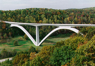
Construction of the parkway was begun by the federal government in the 1930s, one of the many projects of the Civilian Conservation Corps during the Great Depression. The road was the proposal of U.S. Congressman T. Jeff Busby of Mississippi, who proposed it as a way to give tribute to the original Natchez Trace. Inspired by the proposal, the Daughters of the American Revolution began planting markers and monuments along the trace. In 1934, the Franklin Delano Roosevelt administration ordered a survey. President Roosevelt signed the legislation to create the parkway on May 18, 1938.[7] Construction on the Parkway began in 1939, and the route was to be overseen by the National Park Service. Its length includes more than 45,000 acres (182 km2) and the towering Natchez Trace Parkway Bridge in Williamson County, Tennessee, completed in 1994 and one of only two post-tensioned, segmental concrete-arch bridges in the world.
The Emergency Appropriations Act of June 19, 1934, allocated initial construction funds and established it as a parkway under National Park Service by the act of May 18, 1938.
Gaps and completion

For many years in the later 20th century, most of the trace had been complete, but owing to a lack of funds, two gaps remained, both in Mississippi. One was a several-mile-long bypass of Jackson, between Interstate 55 at Ridgeland and Interstate 20 at Clinton. The other was between Liberty Road in the city of Natchez and U.S. Highway 61 near Washington. These final two segments were finally completed and opened on May 21, 2005.
In 2013, a new law required the National Park Service (NPS) to convey about 67 acres of property in the Natchez Trace Parkway to the State of Mississippi. It also adjusted the boundaries of the parkway to include 10 additional acres. The two pieces of land in question originally belonged to Mississippi and were donated to the NPS when it was trying to determine where to end the Natchez Trace Parkway.[8][9][10]
Historical sites

Numerous historical sites on the Parkway include the Meriwether Lewis Museum, the refurbished Mount Locust stand, Historic French Camp, MS, and the Mississippi Craft Center in Ridgeland, Mississippi, which focuses on promoting Mississippi's native art. Between the Parkway and Old Port Gibson Road is the ghost town of Rocky Springs that thrived in the late 19th century. The old Rocky Springs Methodist Church, the cemetery, and several building sites still exist and are accessible from the parkway. Cypress Swamp is located at mile post 122. Also, several cascading waterfalls can be viewed; for access, some require a bit of hiking from the parkway. Besides, parts of the original trail are still accessible. The history of the Natchez Trace, including the parkway, is summarized at the Natchez Trace Visitor Center in Tupelo.[11]
Emerald Mound, the second-largest Native American ceremonial mound in the United States, is located just west of the trace and north of Highway 61 near Natchez. It offers a unique look at the ingenuity and industry of native culture. Two smaller mounds rise from the top of the main mound and rise above treetops, offering a wide view. Travelers can reach Emerald Mound with a five-minute detour from the main trace highway. Emerald Mound measures 770 feet (230 m) by 435 feet (133 m) at the base and is 35 feet (11 m) in height. The mound was built by depositing earth along the sides of a natural hill, thus reshaping it and creating an enormous artificial plateau.
The Ackia Battleground National Monument (established August 27, 1935, and now called Chickasaw Village) and Meriwether Lewis Park (proclaimed as Meriwether Lewis National Monument February 6, 1925, and transferred from the War Department August 10, 1933) were added to the parkway by the act of August 10, 1961.
Parkway highlights
Highlights include:
Natchez to Jackson
- Milepost 10.3 Emerald Mound
- 15.5 Mount Locust
- 41.5 Sunken Trace
- 54.8 Abandoned Town of Rocky Springs
Jackson to Tupelo
- Milepost 105.6 Ross Barnett Reservoir Overlook
- 107.9 West Florida Boundary
- 122.0 Cypress Swamp
- 203.5 Historic settlement of Pigeon Roost
- 232.4 Bynum Mounds
- 261.8 Chickasaw Village Site
Tupelo to Tennessee state line
- Milepost 266 Natchez Trace Parkway Visitor Center
- 269.4 Old Trace
- 286.7 Pharr Mounds
- 327.3 Colbert Ferry, also site #12 on the North Alabama Birding Trail
- 330.2 Rock Spring Nature Trail, also site #10 on the North Alabama Birding Trail
Tennessee
- Milepost 385.9 Meriwether Lewis Monument and Grave Site
- 391.9 Fall Hallow Trail
- 401.4 Tobacco Farm and Old Trace Drive
- 404.7 Trail to Jackson Falls and Baker Bluff Overlook
- 438 Bridge at Birdsong Hollow
Exit list
Mileage based on physical mileposts along the parkway.
| State | County | Location | mi[12] | km | Destinations[12] | Notes |
|---|---|---|---|---|---|---|
| Mississippi | Adams | Natchez | 0 | 0.0 | Liberty Road | Southern terminus |
| | 4 | 6.4 | Elizabeth Female Academy | |||
| | 8 | 13 |  US 61 – Fayette, Natchez US 61 – Fayette, Natchez | Partial cloverleaf interchange | ||
| | Old Trace Exhibit | |||||
| | 10 | 16 |  MS 553 – Emerald Mound site, Natchez State Park MS 553 – Emerald Mound site, Natchez State Park | At-grade intersection | ||
| Jefferson | | 12 | 19 | Turpin Creek | ||
| | Loess Bluff | |||||
| | 15 | 24 | Mount Locust | |||
| | 17 | 27 | Coles Creek | |||
| | 18 | 29 | Bullen Creek | |||
| | 20 | 32 | MS 553 – Natchez Trace Trail (Potkopinu Section), Fayette | One-quadrant interchange | ||
| | Mud Island | |||||
| | 23 | 37 | North Fork Coles Creek | |||
| | 27 | 43 | Coonbox | |||
| | 30 | 48 |  MS 552 – Windsor Ruins, Lorman, Alcorn State University MS 552 – Windsor Ruins, Lorman, Alcorn State University | Two-quadrant interchange | ||
| Claiborne | | 37 | 60 |  US 61 – Port Gibson US 61 – Port Gibson | One-quadrant interchange | |
| | 39 | 63 | Port Gibson District Office | |||
| | 41 | 66 |  MS 18 – Port Gibson, Utica, Grand Gulf Military State Park MS 18 – Port Gibson, Utica, Grand Gulf Military State Park | One-quadrant interchange | ||
| | Sunken Trace | |||||
| | 45 | 72 | Grindstone Ford and Mangum Mound | |||
| | 52 | 84 | Owens Creek Waterfall | |||
| | 54 | 87 | Rocky Springs | |||
| | 59 | 95 | Fisher Ferry Road – Utica | One-quadrant interchange | ||
| | 61 | 98 | Lower Choctaw Boundary | |||
| Hinds | | 66 | 106 |  MS 27 – Utica, Vicksburg MS 27 – Utica, Vicksburg | One-quadrant interchange | |
| | 73 | 117 | Dean Stand Site | |||
| | 78 | 126 | Battle of Raymond | |||
| |  MS 467 – Raymond, Edwards MS 467 – Raymond, Edwards | One-quadrant interchange | ||||
| | 82 | 132 |  Airport Road – John Bell Williams Airport Airport Road – John Bell Williams Airport | |||
| | 86 | 138 | Clinton Pullout | |||
| Clinton | 86– 87 | 138– 140 |  I-20 – Vicksburg, Clinton, Jackson I-20 – Vicksburg, Clinton, Jackson | Partial cloverleaf interchange; I-20 exit 34 | ||
| 87 | 140 | Cowles Mead Cemetery | ||||
| 88 | 142 | Pinehaven Drive – City of Clinton Visitor Center | One-quadrant interchange | |||
| 89 | 143 | Ridgeland Pullout | ||||
| Jackson | 92– 93 | 148– 150 |  US 49 – Flora, Jackson US 49 – Flora, Jackson | Partial cloverleaf interchange | ||
| 93 | 150 | Osburn Stand | ||||
| Madison | Ridgeland | 100 | 160 | Choctaw Agency | ||
| 101 | 163 |  I-55 – Madison, Jackson I-55 – Madison, Jackson | Partial cloverleaf interchange; I-55 exit 105A | |||
| 102 | 164 |  US 51 – Parkway Information Cabin US 51 – Parkway Information Cabin | One-quadrant interchange | |||
| Ridgeland District Office | ||||||
| 103 | 166 | Old Canton Road – Madison, Ridgeland, Bruce Campbell Field | Partial cloverleaf interchange | |||
| 104 | 167 | Old Trace and Brashears Stand Site | ||||
| | 105 | 169 | Reservoir Overlook | |||
| | 106 | 171 | Boyd site | |||
| | 107 | 172 | West Florida Boundary | |||
| | 114– 115 | 183– 185 |  MS 43 – Canton, Pelahatchie, Ross Barnett Reservoir MS 43 – Canton, Pelahatchie, Ross Barnett Reservoir | Two-quadrant interchange | ||
| | 122 | 196 | Cypress Swamp | |||
| | River Bend | |||||
| | 128 | 206 | Upper Choctaw Boundary | |||
| | 130 | 210 | Yockanookany | |||
| Leake | | 134– 135 | 216– 217 |  MS 16 – Canton, Carthage MS 16 – Canton, Carthage | Two-quadrant interchange | |
| | 135 | 217 | Robinson Road | |||
| | 140 | 230 | Red Dog Road | |||
| | 145 | 233 | Myrick Creek | |||
| | 146 | 235 |  MS 429 – Thomastown MS 429 – Thomastown | At-grade intersection | ||
| Attala | | 154 | 248 | Holly Hill | ||
| | 159 | 256 | Kosciusko District Office | |||
| | 159– 160 | 256– 260 |  MS 19 – Kosciusko, Carthage MS 19 – Kosciusko, Carthage | Two-quadrant interchange | ||
| | Kosciusko Welcome Center | |||||
| | 164 | 264 | Hurricane Creek | |||
| | 165 | 266 |  MS 12 – Ethel, Kosciusko MS 12 – Ethel, Kosciusko | Two-quadrant interchange | ||
| | 169 | 272 | CR 2247 to CR 2101 | One-quadrant interchange | ||
| | 175 | 282 | Cole Creek | |||
| | 176 | 283 | Bethel Mission | |||
| Choctaw | French Camp | 180 | 290 | French Camp South | ||
   MS 413 to MS 407 MS 413 to MS 407 | At-grade intersection | |||||
| French Camp | ||||||
| 181 | 291 | French Camp North | ||||
| | 189 | 304 | Byway Overlook | |||
| | 190 | 310 |  MS 415 MS 415 | Northern terminus of MS 415 | ||
| | 193 | 311 | Jeff Busby | |||
| | 195 | 314 |  MS 9 – Choctaw Lake Recreation Area, Eupora, Ackerman MS 9 – Choctaw Lake Recreation Area, Eupora, Ackerman | One-quadrant interchange | ||
| | 198 | 319 | Old Trace | |||
| | 201 | 323 | Ballard Creek | |||
| | 203 | 327 | Pigeon Roost | |||
| Webster | | 204 | 328 |  US 82 – Eupora, Mathiston US 82 – Eupora, Mathiston | Partial cloverleaf interchange | |
| | 210 | 340 |   MS 765 to MS 50 MS 765 to MS 50 | Western terminus of MS 765 | ||
| | 213 | 343 | Line Creek | |||
| | 214 | 344 |  MS 15 – Maben, Houston MS 15 – Maben, Houston | One-quadrant interchange | ||
| | Dancy District Office | |||||
| Clay | | 219 | 352 |  MS 46 – Mantee, Montpelier MS 46 – Mantee, Montpelier | One-quadrant interchange | |
| Chickasaw | | 221 | 356 | Old Trace | ||
| | 226 | 364 |  MS 389 – Houston, Montpelier MS 389 – Houston, Montpelier | One-quadrant interchange | ||
| | 229 | 369 |  MS 8 – Houston, Aberdeen MS 8 – Houston, Aberdeen | One-quadrant interchange | ||
| | 232 | 373 | Bynum Mounds | |||
| | 233 | 375 | Witch Dance | |||
| | 235 | 378 | Old Fossils | |||
| | 239 | 385 |  MS 32 – Houston, Okolona MS 32 – Houston, Okolona | One-quadrant interchange | ||
| | 241 | 388 | Chickasaw Agency | |||
| | 243 | 391 |  CR 413 – Owl Creek Mounds CR 413 – Owl Creek Mounds | One-quadrant interchange | ||
| | Hernando de Soto | |||||
| | 245 | 394 | Monroe Mission | |||
| Pontotoc | | 246 | 396 |  MS 41 – Pontotoc, Okolona MS 41 – Pontotoc, Okolona | One-quadrant interchange | |
| | 249 | 401 | Tockshish | |||
| | 251 | 404 | Chickasaw Council House | |||
| Lee | | Pontocola Road – Pontotoc, Shannon | One-quadrant interchange | |||
| | 252 | 406 | Black Belt Overlook | |||
| | 255 | 410 | Palmetto Road – Pontotoc, Verona | One-quadrant interchange | ||
| | 256 | 412 |   US 278 / MS 6 US 278 / MS 6 | Partial cloverleaf interchange | ||
| Tupelo | 258 | 415 | Cliff Gookin Boulevard – Tupelo High School | Two-quadrant interchange | ||
| 259– 260 | 417– 420 | Main Street – Tupelo, Pontotoc, Tupelo National Battlefield | Two-quadrant interchange | |||
| 261 | 420 | Chickasaw Village Site | ||||
| 262 | 422 |  MS 178 (McCullough Boulevard) – Elvis Presley Birthplace MS 178 (McCullough Boulevard) – Elvis Presley Birthplace | Two-quadrant interchange | |||
| 263 | 423 |   I-22 / US 78 – Tupelo, Fulton, New Albany, Tombigbee State Park, Elvis Presley Lake I-22 / US 78 – Tupelo, Fulton, New Albany, Tombigbee State Park, Elvis Presley Lake | Partial cloverleaf interchange; I-22 exit 85 | |||
| Old Town Overlook | ||||||
| | 265– 266 | 426– 428 | Parkway Visitor Center | |||
| | 266 | 428 |  MS 145 – Tupelo, Corinth MS 145 – Tupelo, Corinth | Two-quadrant interchange | ||
| | 269 | 433 | Old Trace and Confederate Gravesites | |||
| | 270 | 430 |  MS 363 – Saltillo, Mantachie MS 363 – Saltillo, Mantachie | Two-quadrant intersection | ||
| | 275 | 443 | Dogwood Valley | |||
| | 275– 276 | 443– 444 | Friendship Road | One-quadrant interchange | ||
| | 278 | 447 | Twentymile Bottom Overlook | |||
| Itawamba | | 281– 282 | 452– 454 |   MS 371 to MS 370 – Marietta, Mantachie, Baldwyn MS 371 to MS 370 – Marietta, Mantachie, Baldwyn | Two-quadrant interchange | |
| | 283 | 455 | Donivan Slough | |||
| Prentiss | | 286 | 460 | Browns Bottom | ||
| | Pharr Mounds | |||||
| | 288 | 463 | Siloam Road – Whitten Lock and Dam, Bay Springs Lake | Partial cloverleaf interchange | ||
| Tennessee–Tombigbee Waterway | 292 | 470 | Jamie L. Whitten Bridge | |||
| Tishomingo | | 293 | 472 | Tenn–Tom Waterway | ||
| |   CR 1 to MS 4 – Fulton, Bay Springs Lake CR 1 to MS 4 – Fulton, Bay Springs Lake | One-quadrant interchange | ||||
| | 295 | 475 | Jourdan Creek | |||
| | 297 | 478 | MS 4 – Belmont, Booneville, Bay Springs Lake | One-quadrant interchange | ||
| | 300 | 480 | McDougal | |||
| | 302– 303 | 486– 488 |  MS 25 – Tishomingo, Belmont MS 25 – Tishomingo, Belmont | Two-quadrant interchange | ||
| | 303 | 488 |  CR 90 – Tishomingo State Park CR 90 – Tishomingo State Park | One-quadrant interchange | ||
| | 307 | 494 |  MS 30 – Booneville MS 30 – Booneville | One-quadrant interchange | ||
| | 308 | 496 | Cave Spring | |||
| | Bear Creek Mound | |||||
| Alabama | Colbert | | 309 | 497 | CR 1 (Allsboro Road) | One-quadrant interchange |
| | 311 | 501 | Rock Creek | |||
| | 312 | 502 | Bear Creek | |||
| | 316 | 509 | Freedom Hills Overlook | |||
| | 320 | 510 |  US 72 – Cherokee, Iuka US 72 – Cherokee, Iuka | One-quadrant interchange | ||
| | Buzzard Roost Spring | |||||
| | 323 | 520 | Sinkhole | |||
| | 326 | 525 |  CR 21 (North Pike) – Cherokee CR 21 (North Pike) – Cherokee | One-quadrant interchange | ||
| | 327 | 526 | Colbert Ferry | |||
| Tennessee River | 327– 328 | 526– 528 | John Coffee Memorial Bridge | |||
| Lauderdale | | 328 | 528 | Lauderdale | ||
| | 329 | 529 |  CR 2 CR 2 | One-quadrant interchange | ||
| | 330 | 530 | Rock Spring | |||
| | 331 | 533 |  CR 14 – Florence, Waterloo CR 14 – Florence, Waterloo | One-quadrant interchange | ||
| | 336 | 541 |  SR 20 – Florence SR 20 – Florence | One-quadrant interchange | ||
| Tennessee | Wayne | | 343 | 552 | Cypress Creek | |
| | 346 | 557 | Holly | |||
| | 350 | 560 | Sunken Trace | |||
| |  SR 13 – Florence, AL SR 13 – Florence, AL | One-quadrant interchange | ||||
| | 352 | 566 | McGlamery Stand | |||
| Collinwood | 354 | 570 | Broadway Street – Wayne County Welcome Center | One-quadrant interchange | ||
| | 363 | 584 | Sweetwater Branch | |||
| | 364 | 586 | Glenrock Branch | |||
| | 365 | 587 | Upper Glenrock Branch | |||
| | 367 | 591 | Dogwood Mudhole | |||
| | 369– 370 | 594– 600 |  US 64 – Lawrenceburg, Waynesboro, David Crockett State Park US 64 – Lawrenceburg, Waynesboro, David Crockett State Park | Partial cloverleaf interchange | ||
| | Trail of Tears Bell Route | |||||
| Lawrence | | 372 | 599 | Brush Creek Road – Laurel Hill Lake | One-quadrant interchange | |
| | 375 | 604 | Old Trace Drive | |||
| Lewis | | 377 | 607 | Jacks Branch Road | One-quadrant interchange | |
| | Jacks Branch | |||||
| | 380 | 610 |  SR 241 (Napier Road) SR 241 (Napier Road) | One-quadrant interchange | ||
| | 381 | 613 | Napier Mine | |||
| | 382 | 615 | Metal Ford | |||
| | 385 | 620 |  SR 20 (Summertown Highway) – Hohenwald, Summertown SR 20 (Summertown Highway) – Hohenwald, Summertown | One-quadrant interchange | ||
| | Meriwether Lewis, near Grinder's Stand | |||||
| | 386 | 621 | English Creek Cascade | |||
| | 390 | 630 | Phosphate Mine | |||
| | 391 | 629 |  US 412 (Columbia Highway) – Columbia, Hohenwald US 412 (Columbia Highway) – Columbia, Hohenwald | One-quadrant interchange | ||
| | Fall Hollow | |||||
| | 392 | 631 | Swan View Overlook | |||
| | 394 | 634 | Devil's Backbone State Natural Area | |||
| | 397 | 639 | Old Trace | |||
| Hickman | | 400 | 640 | Sheboss Place | ||
| Maury | | 401 | 645 | Tobacco Farm and Old Trace | ||
| Hickman | | 403 | 649 | Old Track Walk | ||
| | 404 | 650 | Jackson Falls | |||
| | 405 | 652 | Baker Bluff Overlook | |||
| Maury | | 407 | 655 | Gordon House | ||
| Hickman | |  SR 50 – Columbia, Centerville SR 50 – Columbia, Centerville | One-quadrant interchange | |||
| Maury | | 411 | 661 | Water Valley Overlook | ||
| | 415 | 668 |  SR 7 – Columbia, Dickson SR 7 – Columbia, Dickson | One-quadrant interchange | ||
| Williamson | | 423 | 681 | Tennessee Valley Divide | ||
| | 425 | 684 | Burns Branch | |||
| | 426 | 686 | War of 1812 | |||
| | 427 | 687 | Garrison Creek | |||
| | 428 | 689 |  SR 46 – Leiper's Fork SR 46 – Leiper's Fork | One-quadrant interchange | ||
| | 435 | 700 | Carroll | |||
| | 437 | 703 | Timberland Park | |||
| |  SR 96 – Franklin SR 96 – Franklin | One-quadrant interchange | ||||
| | 437– 438 | 703– 705 | Natchez Trace Parkway Bridge | |||
| | 438 | 705 | Birdsong Hollow | |||
| | 439 | 707 | Bending Chestnut Overlook | |||
| | 442 | 711 |   SR 100 to McCrory Lane / I-40 SR 100 to McCrory Lane / I-40 | Modified trumpet interchange; northern terminus | ||
| 1.000 mi = 1.609 km; 1.000 km = 0.621 mi | ||||||
Gallery
 Natchez Trace Parkway Bridge over SR 96 in Tennessee
 Rocky Springs Methodist Church
 Rocky Springs Cemetery
 Cypress Swamp
 Scenic waterfall
 Meriwether Lewis National Monument and gravesite at Grinder's Stand
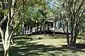 Mount Locust
See also
References
- ↑ "Natchez Trace Parkway". National Park Service. Retrieved August 24, 2016.
- 1 2 AN ACT To provide for the administration and maintenance of the Natchez Trace Parkway, in the States of Mississippi, Alabama, and Tennessee, by the Secretary of the Interior, and for other purposes. 52 Stat. 407, enacted 18 May 1938.
- ↑ "Listing of acreage – December 31, 2011" (XLSX). Land Resource Division, National Park Service. Retrieved 2012-03-18. (National Park Service Acreage Reports)
- ↑ "Annual Visitation Highlights". nps.gov. National Park Service. Retrieved 10 July 2020.
- ↑ The National Parks: Index 2001-2003. Washington: U.S. Department of the Interior
- ↑ National Park Service, Natchez Trace Parkway Fact Sheet, February 25, 2010
- 1 2 "Distribution of Administrative History, Natchez Trace Parkway" (PDF). National Park Service. p. 177. Archived from the original (Scanned into Adobe Acrobat (PDF)) on 2007-07-02. Retrieved 2007-08-10.
- ↑ "House Republican Conference's Legislative Digest on S 304". House Republican Conference. Archived from the original on 7 January 2014. Retrieved 13 September 2013.
- ↑ "Congress passes bill to give city 'bean field' property". Natchez Democrat. 11 September 2013. Retrieved 13 September 2013.
- ↑ S. 304
- ↑ Scott, David (2004). Guide to the National Park Areas Eastern States. Guilford, Conn: Globe Pequot Press. pp. 151–153. ISBN 0-7627-2988-0. OCLC 55075855.
- 1 2 "Maps - Natchez Trace Parkway (U.S. National Park Service)". www.nps.gov. National Park Service. Retrieved July 2, 2021.
External links


- "Guide to records (general administrative files) of Natchez Trace National Parkway". OurArchives.wikispaces.net. Archived from the original on 22 February 2013.
- "Natchez Trace Parkway". National Park Service.
- "The Natchez Trace Compact". ScenicTrace.com.
- Federal Highway Administration's photo of the Natchez Trace Parkway Bridge
- Historic American Engineering Record (HAER) No. MS-15, "Natchez Trace Parkway, Between Natchez, MS, and Nashville, TN, Tupelo, Lee County, MS", 95 photos, 10 color transparencies, 15 measured drawings, 106 data pages, 8 photo caption pages