25°03′12″N 121°36′27″E / 25.053315°N 121.607409°E
Nangang
南港區 Nankang; NanKang; Nan-kang; Nan-chiang | |
|---|---|
| Nangang District | |
 | |
 | |
| Country | Republic of China (Taiwan) |
| Region | Eastern Taipei |
| Divisions | List
|
| Area | |
| • Total | 21.8424 km2 (8.4334 sq mi) |
| • Rank | Ranked 5th of 12 |
| Population (January 2023) | |
| • Total | 113,920 |
| • Rank | Ranked 12th of 12 |
| • Density | 5,200/km2 (14,000/sq mi) |
| Postal code | 115 |
| Website | ngdo |
| Nangang District | |||||||||||||||
|---|---|---|---|---|---|---|---|---|---|---|---|---|---|---|---|
| Traditional Chinese | 南港區 | ||||||||||||||
| |||||||||||||||

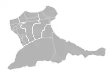
Nangang[2][3] District (Chinese: 南港區), also Nankang,[4] is a southeastern district of Taipei, Taiwan. It is the seat of the Academia Sinica, Taipei World Trade Center Nangang Exhibition Hall, and Nankang Software Park (NKSP).
History
Nangang was settled in 1735 by Fujianese, especially in the present villages of Nangang, Sanchong, and Dongxin. The placename was Toakalah (Chinese: 大佳臘; Pe̍h-ōe-jī: Tōa-ka-la̍h),[5] Nangang-Sanchong Port (南港三重埔; Lâm-káng Saⁿ-têng-po͘). The Qing era name of Lamkang'a (南港仔; Lâm-káng-á; 'southern port'), refers to its position on Keelung River.
In 1920, during the Japanese era, Nangang was part of Naiko Village (内湖庄), Shichisei District (七星區), Taihoku Prefecture. In December 1945, after the handover of Taiwan to the Kuomintang, the administrative levels were changed to Neihu Township (內湖鄉), Qixing District (七星區), Taipei County. July 6 the following year, as proposed by Mayor Que Shankeng (闕山坑), Nangang was separated into its own township (南港鎮). In 1968, it became a district of Taipei. [6]
Administration
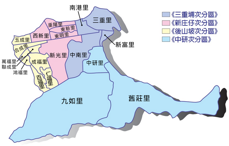
| Region[7] | Type | Chinese[1] | Hanyu Pinyin | Wade–Giles | Pe̍h-ōe-jī | Notes |
|---|---|---|---|---|---|---|
| 中研次分區 | Urban villages |
舊莊里 | Jiùzhuāng | Chiuchuang | Kū-chng | |
| 九如里 | Jiǔrú | Chiuju | Kiú-jû | |||
| 中研里 | Zhōngyán | Chungyen | Tiong-gián | part of Jiuzhuang until December 1974, contains the Academia Sinica | ||
| 三重埔次分區 | 中南里 | Zhōngnán | Chungnan | Tiong-lâm | ||
| 新富里 | Xīnfù | Hsinfu | Sin-hù | |||
| 南港里 | Nángǎng | Nankang | Lâm-káng | |||
| 三重里 | Sānchóng | Sanch'ong | San-tiông | |||
| 新庄仔次分區 | 西新里 | Xīxīn | Hsihsin | Se-sin | ||
| 東明里 | Dōngmíng | Tungmin | Tang-bêng | |||
| 東新里 | Dōngxīn | Tunghsin | Tang-sin | |||
| 新光里 | Xīnguāng | Hsinkuang | Sin-kong | |||
| 重陽里 | Chóngyáng | Tiông-iông | ||||
| 後山坡次分區 | 成福里 | Chéngfú | Sêng-hok | |||
| 百福里 | Bǎifú | Pah-hok | ||||
| 聯成里 | Liánchéng | Liench'eng | Liân-sêng | |||
| 玉成里 | Yùchéng | Yüch'eng | Gio̍k-sêng | |||
| 鴻福里 | Hóngfú | Hông-hok | ||||
| 萬福里 | Wànfú | Bān-hok | ||||
| 合成里 | Héchéng | Hoch'eng | Ha̍p-sêng | |||
| 仁福里 | Rénfú | Jenfu | Jîn-hok |
Government institutions
Education
Economy
Miscellaneous
Tourist attractions
- Lingnan Fine Arts Museum
- Taipei Nangang Exhibition Center
- Nanhu Riverside Park
- Nanxing Park
- Nangang Park
- Shanshuilu Eco Park
- Taipei Nangang Sports Center
Transportation

Metro
Highways and Roads
- Freeway 3
- Freeway 5
- Provincial Highway 5
- Huandong Boulevard
- City Route 109
Notable people
- Roy Chiu, actor, singer and racing driver
See also
References
- 1 2 區里分布 (in Chinese (Taiwan)). 30 December 2015. Retrieved 22 June 2019.
本區面積為21.8424平方公里,並畫分為舊莊里、九如里、中研里、中南里、新富里、南港里、三重里、西新里、東明里、東新里、新光里、重陽里、成福里、百福里、聯成里、玉成里、鴻福里、萬福里、合成里、仁福里等20個里。 南港區區里分布圖
- ↑ "Administrative Districts". Taipei City Government. 13 March 2018. Retrieved 22 June 2019.
There are 12 administrative districts in the Taipei City, including {...} Nangang, {...}
- ↑ Nangang (Approved - N) at GEOnet Names Server, United States National Geospatial-Intelligence Agency
- ↑ 胡適紀念館 (PDF). 2017. Retrieved 27 June 2019.
Nankang, Taipei 115, Taiwan, R.O.C.
- ↑ "Entry #40020". 臺灣閩南語常用詞辭典 [Dictionary of Frequently-Used Taiwan Minnan]. (in Chinese and Hokkien). Ministry of Education, R.O.C. 2011.
- ↑ "Taipei City Government". 28 July 2009.
- ↑ 南港區區里分布圖 (in Chinese (Taiwan)). Retrieved 22 June 2019.
《三重埔次分區》《新庄仔次分區》《後山坡次分區》《中研次分區》
External links

- Official website
 (in Chinese)