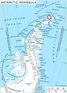
Location of Astrolabe Island in the Antarctic Peninsula region.

Astrolabe Island from northwest, Drumohar Peak is the left one of the two prominent mountains dominating the island.
Drumohar Peak (Bulgarian: връх Друмохар, romanized: vrah Drumohar, IPA: [ˈvrɤɣ dromoˈxar]) is the ice-covered peak rising to 437 m[1] in the northeastern part of Astrolabe Island off Trinity Peninsula, Antarctica.
The peak is named after the settlement of Drumohar in Western Bulgaria.
Location
Drumohar Peak is located at 63°18′26″S 58°40′55″W / 63.30722°S 58.68194°W, which is 3.15 km east of Raduil Point and 1.9 km north-northwest of Rogach Peak. German-British mapping in 1996.
Maps
- Trinity Peninsula. Scale 1:250000 topographic map No. 5697. Institut für Angewandte Geodäsie and British Antarctic Survey, 1996.
- Antarctic Digital Database (ADD). Scale 1:250000 topographic map of Antarctica. Scientific Committee on Antarctic Research (SCAR). Since 1993, regularly upgraded and updated.
Notes
- ↑ Reference Elevation Model of Antarctica. Polar Geospatial Center. University of Minnesota, 2019
References
- Drumohar Peak. SCAR Composite Antarctic Gazetteer.
- Bulgarian Antarctic Gazetteer. Antarctic Place-names Commission. (details in Bulgarian, basic data in English)
External links
- Drumohar Peak. Copernix satellite image
This article includes information from the Antarctic Place-names Commission of Bulgaria which is used with permission.
This article is issued from Wikipedia. The text is licensed under Creative Commons - Attribution - Sharealike. Additional terms may apply for the media files.