| Supraśl | |
|---|---|
.jpg.webp) Supraśl near village Studzianki | |
| Location | |
| Country | Poland |
| Physical characteristics | |
| Source | |
| • location | near village Topolany |
| • elevation | 110 m (360 ft) |
| Mouth | |
• location | Narew in Złotoria |
• coordinates | 53°10′39″N 22°56′15″E / 53.177590°N 22.937635°E |
| Length | 93.8 km (58.3 mi) |
| Basin size | 1,844.4 km2 (712.1 sq mi) |
| Basin features | |
| Progression | Narew→ Vistula→ Baltic Sea |
Supraśl - is a river in east Poland in Podlaskie Voivodeship, a tributary of the Narew river (near Złotoria), with a length of 93,8 kilometres and the basin area of 1844,4 km2.
Supraśl is the source of the drinking water for Białystok.
Tributaries
Słoja (r), Sokołda (r), Kamionka (l), Płoska (l), Pilnica (l), Czarna (r), Biała (l)
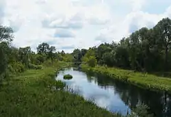
Supraśl River near city Supraśl
Cities and towns
This article is issued from Wikipedia. The text is licensed under Creative Commons - Attribution - Sharealike. Additional terms may apply for the media files.