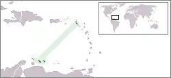
The location of the former nation of the Netherlands Antilles
The following is an alphabetical list of topics related to the former nation of the Netherlands Antilles.
0–9
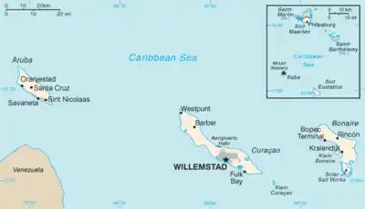
A map of the former Netherlands Antilles
- .an – Internet country code top-level domain for the Netherlands Antilles
A
- ABC islands
- Adjacent country:

- Air Force of the Netherlands Antilles
- Americas
- Antillenhuis, the cabinet of the minister plenipotentiary of the Netherlands Antilles in the Hague
- Antilles
- Army of the Netherlands Antilles
- Atlantic Ocean
- Atlas of the Netherlands Antilles
B
- BES Islands — a genuine abbreviation for the islands of Bonaire, Sint Eustatuis, and Saba
C
.svg.png.webp)
.svg.png.webp)
Coat of arms of the Netherlands Antilles after Aruba seceded in 1986
- Capital of the Netherlands Antilles: Willemstad on Curaçao
- Caribbean
- Caribbean Netherlands (the BES Islands as separate from Curaçao and Sint Maarten)
- Caribbean Community (CARICOM)
- Caribbean Sea
- Categories:
- Category:Netherlands Antilles
- Category:Bonaire
- Category:Curaçao
- Category:Saba (island)
- Category:Sint Eustatius
- Category:Sint Maarten
- Category:Communications in the Netherlands Antilles
- Category:Dutch Antillean culture
- Category:Dutch Antillean people
- Category:Economy of the Netherlands Antilles
- Category:Education in the Netherlands Antilles
- Category:Environment of the Netherlands Antilles
- Category:Geography of the Netherlands Antilles
- Category:Government of the Netherlands Antilles
- Category:History of the Netherlands Antilles
- Category:Netherlands Antilles stubs
- Category:Netherlands Antilles-related lists
- Category:Politics of the Netherlands Antilles
- Category:Society of the Netherlands Antilles
- Category:Sport in the Netherlands Antilles
- Category:Transport in the Netherlands Antilles
- commons:Category:Netherlands Antilles
- Category:Netherlands Antilles
- Cities of the Netherlands Antilles
- Climate of the Netherlands Antilles
- Coast guard – Netherlands Antilles & Aruba Coast Guard
- Coat of arms of the Netherlands Antilles
- Constitution of the Netherlands Antilles
D
E
F
.svg.png.webp)
.svg.png.webp)
Flag of the Netherlands Antilles after Aruba seceded in 1986
G
H
I
- International Organization for Standardization (ISO)
- ISO 3166-1 alpha-2 country code for the Netherlands Antilles: AN
- ISO 3166-1 alpha-3 country code for the Netherlands Antilles: ANT
- Internet in the Netherlands Antilles
- Islands of the Caribbean
- Islands of the Netherlands Antilles:
- Bonaire
- Curaçao
- Saba
- Sint Eustatius
- Sint Maarten, the southern portion of the island of Saint Martin
- minor islands:
- Camia, Netherlands Antilles
- Cow and Calf
- Green Island, Netherlands Antilles
- Guana Cay
- Hen and Chicken
- Isla Makuka
- Kadoesji
- Little Island, Netherlands Antilles
- Little Key, Netherlands Antilles
- Mal Aborder
- Meeuwtje
- Mollibeday Rots
- Mona Island, Netherlands Antilles
- Pelican Island, Netherlands Antilles
- Penso, Netherlands Antilles
- Rancho, Netherlands Antilles
- Sapate Eliand
- Willemberg
K
L
- Lesser Antilles
- Lists related to the Netherlands Antilles:
- List of airports in the Netherlands Antilles
- List of birds of the Netherlands Antilles
- List of cities in the Netherlands Antilles
- List of countries by GDP (nominal)
- List of islands of the Netherlands Antilles
- List of Netherlands Antilles-related topics
- List of political parties in the Netherlands Antilles
- List of rivers of the Netherlands Antilles
- List of universities in the Netherlands Antilles
- List of volcanoes in the Netherlands Antilles
- List of World Heritage Sites in the Netherlands Antilles
- Topic outline of the Netherlands Antilles
M
N
O
P
S
T
U
W
- Western Hemisphere
 Wikimedia Atlas of the Netherlands Antilles
- Wikipedia:WikiProject Topic outline/Drafts/Topic outline of the Netherlands Antilles
- Willemstad on Curaçao – Capital of the Netherlands Antilles
See also
- All pages with titles beginning with Netherlands Antilles
- All pages with titles beginning with Dutch Antillean
- All pages with titles containing Netherlands Antilles
- All pages with titles containing Dutch Antillean
- List of Caribbean-related topics
- List of international rankings
- Lists of country-related topics
- Topic outline of geography
- Topic outline of North America
- Topic outline of South America
- Topic outline of the Netherlands Antilles
References
- ↑ Greater North America may be geographically subdivided into Northern America, Central America, and the Caribbean.
- ↑ The West Indies comprise the Antilles and the Lucayan Archipelago.
- 1 2 Since the Netherlands Antilles are located in the Caribbean Sea, they are usually considered a part of greater North America. Because of the proximity of Aruba, Curaçao, and Bonaire to the continent of South America, those islands may also be considered a part of greater South America.
External links
This article is issued from Wikipedia. The text is licensed under Creative Commons - Attribution - Sharealike. Additional terms may apply for the media files.